
For more than sixty years, weather prediction has meant dividing the atmosphere into a three-dimensional grid and solving the equations of fluid motion on supercomputers. That framework has now met a genuine rival. Deep learning systems can produce a 10-day global forecast in under a minute, and in the right conditions they match or beat physics-based models on headline accuracy scores. The result is a quiet infrastructure shift with real consequences for forecast quality, energy grids, and disaster warnings, and it deserves a clearer explanation than chatbot headlines usually give it.
The honest picture is narrower than the hype. Modern AI weather forecasting models are fast statistical emulators trained on decades of past weather. They are excellent at large-scale flow several days ahead, weaker at surface detail and heavy rainfall, and only a few of them actually run as operational forecast systems. The rest are research models tested on historical data.
How AI forecasting differs from physics-based models
Traditional numerical weather prediction (NWP), such as the Integrated Forecasting System (IFS) run by the European Centre for Medium-Range Weather Forecasts (ECMWF) or the Global Forecast System (GFS) run by NOAA, starts from physics. Supercomputers take the current state of the atmosphere and step equations for mass, momentum, and heat forward in time. Because small-scale processes like cloud formation and turbulence are too fine for the grid, models approximate them using simplified formulas called parameterizations. A full cycle takes hours on thousands of processor cores.
AI weather forecasting skips the step-by-step physics at run time. Models such as GraphCast, Pangu-Weather, FourCastNet, and FuXi learn patterns from massive historical archives, above all ERA5 reanalysis, which reconstructs the past 40-plus years of global atmosphere on a roughly 31 km grid. Given the state of the atmosphere now, the network predicts the state six hours later, then feeds its own output back in, rolling forward to day 10. Training takes weeks on large GPU clusters, but a finished forecast takes tens of seconds on a handful of GPUs.
That trade explains both the promise and the problem. Optimizing for average error across millions of grid points rewards smooth, broadly correct flow, but nothing in a pure neural network enforces conservation of mass, moisture, or energy. When the weather turns sharp and local, the statistics blur what the physics would keep crisp.
What the benchmarks actually show
Every claim that an AI model beats a physics-based system traces to a specific verification study, measured on specific variables at specific lead times. Without those qualifiers, the claim is misleading.
The landmark result came from Lam et al. (Science, 2023) on GraphCast. Verified against ERA5 and operational analysis across 1,380 targets, GraphCast had lower root-mean-square error (RMSE, a standard measure of average forecast discrepancy) than ECMWF’s high-resolution physics model (IFS HRES) on 90% of targets for 10-day forecasts at 0.25-degree resolution (roughly 28 km at the equator). The headline variable was 500 hPa geopotential height (Z500), the mid-atmosphere pressure level around 5.5 km altitude that tracks large-scale steering winds and weather systems, at lead times of 3 to 10 days. At lead times under a day, where data assimilation (blending fresh weather observations into a live starting picture) dominates, the advantage shrank or vanished.
Later models show the same split. Microsoft’s Aurora reported lower RMSE than IFS HRES on about 92% of target variable, level, and lead-time combinations, with gains largest beyond about 12 hours; at the very shortest leads, IFS HRES still led on many targets. Huawei’s Pangu-Weather (Bi et al., Nature, 2023) matched or beat HRES on many upper-air metrics for its 2018 test year, but skill fell away near the surface, especially for 10-meter wind and humidity. FuXi showed competitive track guidance for tropical cyclones out to about a week, with weaker skill on intensity metrics such as minimum central pressure.
The pattern is consistent: AI models earn their strongest wins on smooth upper-air fields such as Z500 and 850 hPa temperature (roughly 1.5 km above sea level) at medium-range leads of roughly 3 to 10 days. Near the surface and inside the first 24 hours, physics-based systems with live data assimilation remain extremely hard to beat.
Where AI models still struggle: rain and record extremes
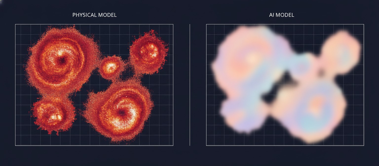
The most consistent weakness is precipitation, above all intense, localized rain. Most models train with mean-squared-error style loss functions that punish a forecast twice for putting a sharp storm slightly in the wrong place, once for missing where it happened and once for false-alarming where it did not. The mathematically safe response is a broad, diluted average: regression to the mean. The result looks like a blurry storm.
A widely cited evaluation by Hamill and colleagues (Geophysical Research Letters, 2024), as reported in secondary summaries, found GraphCast and Pangu-Weather underestimating 99th-percentile precipitation events by roughly 20 to 35% against observations, with high-resolution physics models keeping sharper peaks. Because this figure comes from secondary summaries of the study rather than direct verification of the primary text, treat it as a reported range for heavy-precipitation cases globally rather than a universal constant. Work on record-breaking extremes (Zhang et al.) found IFS HRES still consistently ahead of GraphCast, operational GraphCast, Pangu-Weather, and FuXi for record heat, cold, and wind, with AI errors growing as events pushed further outside the training record.
The April 2024 Dubai downpour is a cautionary case. GraphCast flagged the large-scale low over the Arabian Peninsula days ahead, an impressive large-scale call, but deterministic (single best-guess) precipitation fields underplayed peak local accumulations. That muted intensity is the whole problem for flash floods.
Which models are operational, and which are research
This distinction matters, and coverage often blurs it. Releasing model weights on GitHub is not the same as issuing public forecasts.
Research and open-weight systems include GraphCast, Pangu-Weather, FourCastNet, and FuXi. Their published skill scores come overwhelmingly from retrospective runs initialized from reanalysis, which is clean, complete historical data. Running live is harder: real-time feeds are noisy, gappy, and arrive late from satellites, aircraft, buoys, and radar. A good reanalysis score does not automatically translate into a good operational score.
Genuinely operational AI forecasting arrived in 2025. ECMWF launched AIFS Single as an operational deterministic model in February 2025, then AIFS ENS, a 51-member AI ensemble (a group of slightly varied forecast runs used to gauge probability and uncertainty), in July 2025, the first operational AI ensemble at a major center. NOAA deployed its AI Global Forecast System (AIGFS) and AI ensemble system (AIGEFS) alongside the physics-based GFS. The UK Met Office describes AI running through its whole chain, from quality control to post-processing. Commercial systems such as Google’s WeatherNext models, which we covered as a launch story, now feed consumer and enterprise products with hourly refreshes and station-trained surface fields.
Even so, no AI model issues official warnings. Legal warnings for hurricanes, severe thunderstorms, and flash floods come from national meteorological services, whose forecasters blend AI guidance, physics ensembles, radar, and local observations before anything reaches the public. Treat any model output as guidance until a national service turns it into a warning.
What better forecasts mean for energy
The energy story is real, though people often state it backward. AI forecasting does not save energy directly by being efficient, though the computer running the model uses far less power per forecast. ECMWF’s widely quoted figure of AIFS using roughly 1,000 times less energy than IFS refers strictly to the supercomputer cost of producing one forecast once the model is trained: minutes on a small cluster of graphics processors versus hours on thousands of conventional supercomputer cores. That is a data-center electricity bill for running the model (inference), not electricity saved on the power grid.
The grid value runs through balancing. Wind and solar output lives and dies on weather, and grid operators must match supply to demand every second. When clouds arrive early or wind drops unexpectedly, operators fire up expensive peaking plants; when renewables over-deliver unexpectedly, operators curtail clean power, throwing it away to protect the grid. Better hour-by-hour wind, sunshine, and demand forecasts let operators schedule storage, line up cross-border trading a day ahead, and hold less fossil-fueled spinning reserve. The savings show up as lower balancing costs and less wasted renewable output, not as electricity conjured by the model itself.
That is why the variables utilities care about—hub-height wind near 100 meters, solar irradiance components, cloud layers, and precipitation for hydropower—sit at the exact frontier where AI models are weakest near the surface. Hourly-refresh systems trained against station observations, the direction WeatherNext 3 and AIFS are pushing, matter more to a grid operator than another tenth of a point off Z500 RMSE.
Frequently asked questions
Will AI models replace human forecasters?
No. Models produce fields in seconds, but forecasters interpret uncertainty, weigh ensemble spreads, check radar and local effects, and carry legal responsibility for warnings. The operational future is a forecaster with faster, richer guidance, not a model with a siren.
Should I trust an AI forecast for a severe storm?
Use it as one input, and follow your national weather service for warnings. AI guidance is strongest for the large-scale setup days ahead and weakest for exact rainfall totals and flash-flood timing, which is precisely what keeps people safe.
The hybrid future
The field is converging on hybrids rather than a knockout. Physics still owns data assimilation, conservation checks, and convection-permitting detail for flash floods and severe storms. Neural networks own rapid medium-range ensembles, cheap ensemble spread, and fast processing of dense satellite data. Systems that wrap learning inside physical constraints, rather than replacing physics outright, are where the next genuine gains look likeliest. For readers, the rule of thumb stays simple: ask which variable, which lead time, and whether the score came from history or from live operations. Any forecast claim that cannot answer those three questions has not earned your trust yet.

