
Sixty-two miles north of the small Quebec community of Magpie, there is a lake called Lake Marsal. It is not remarkable. Around it stretches ordinary boreal forest, swamp and rock, the kind of landscape that satellite imagery renders as a fairly uniform green-grey.
But in 2024, an amateur astronomer named Joël Lapointe was scrolling through online satellite maps, trying to plot a camping route through the Côte-Nord region, when he stopped on one particular spot. Something about the shape looked wrong. There was a subtle circular feature centred on the lake, roughly 25 kilometres across, and it did not look like a normal depression or a glacial lake.
Lapointe suspected it might be an impact crater. He was right. As of 2026, it is the largest impact crater discovered on Earth since Hiawatha, found in 2018 under the Greenland ice sheet, and one of roughly 200 confirmed impact structures on our planet.
What makes this story worth more than a footnote is that the site sat in plain sight, in published geological mapping, and had an entirely reasonable explanation attached to it. Nobody was being careless. The rocks genuinely looked volcanic. It took a stranger’s odd hunch to send specialists back to look a second time.
What a Camping Plan Turned Up at Lake Marsal
The sequence matters, because it explains how a feature of this size stayed off the confirmed list for as long as it did.
Lapointe noticed the feature while planning a camping trip in 2024. Rather than assume he had made an error, he contacted specialists in both Europe and North America. One of them was French geophysicist Pierre Rochette, who looked at the topography and reportedly called it “very suggestive” of an impact structure.
That was enough for a team of French researchers to formally list the Lake Marsal area as the possible site of Quebec’s eleventh known impact structure at a 2024 meeting of the Meteoritical Society. The listing brought it to the attention of Gordon Osinski, a planetary geologist at Western University in London, Ontario, who directs the Impact Earth database, the international register of confirmed impact sites.
Osinski was, by his own account, initially sceptical. What changed his mind was an expedition organised by CEREGE, a multidisciplinary research centre in France, which travelled to the site in October 2025.
The logistics were unexpectedly punishing. The team arrived by floatplane, but the water was too shallow to reach the shore, so they waded roughly 50 metres through knee-deep water while carrying their equipment. The ground beyond was swampy, rugged, thick with insects and, in Osinski’s description, covered in “deep, twisty, gnarly vegetation.” Despite years of fieldwork across six continents, he called it one of the most difficult expeditions he had joined.
By the second day, the group had found what it came for.
Geologists Had Blamed These Rocks on a Volcano
Here is the part that most retellings skip.
Previous geological mapping of the Lake Marsal area had identified the fragmented rocks across the site as breccia and had interpreted them as the product of a volcanic feature called a diatreme. A diatreme is a roughly funnel-shaped pipe of broken rock left behind when gas-rich magma erupts explosively and the surrounding country rock collapses into the conduit. They are common, and they produce exactly the kind of jumbled, brecciated material that a large impact also produces.
So the site was not merely overlooked. It had been actively and reasonably misclassified. Two very different processes fragment rock violently. Telling them apart from a satellite image is not really possible, which is precisely why the mistake lasted.
Initial sampling had also turned up zircon, a mineral that can form under the extreme pressures of an impact. That was suggestive rather than conclusive, because zircon can form in plenty of other settings. Zircon alone would not have settled the argument.
What settled it was something you can hold in your hand.
Shatter Cones: The Clue You Can Hold in Your Hand
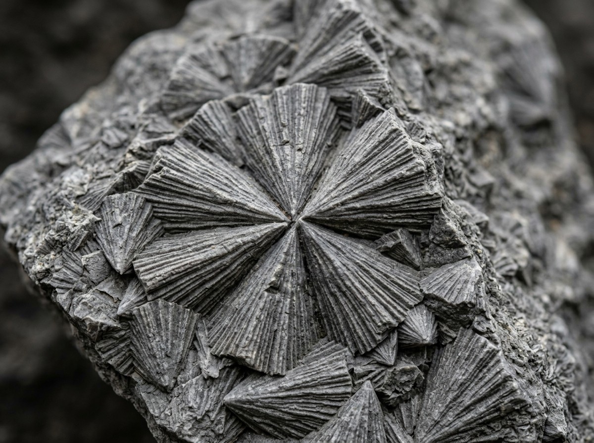
Shatter cones are distinctive conical fractures that appear in rock at a shock structure. They are distinctive because almost nothing else in geology makes them. They were first formally recognised at the Steinheim impact structure in Germany, and as of recent fieldwork they have been found only in impact craters, their ejecta, and in meteorites.
Gordon Osinski described them as “the only unequivocal evidence of an impact event that you can see in the field with the naked eye.” That is the key property. Many diagnostic criteria for an impact require laboratory work: shocked quartz, high-pressure mineral phases like coesite and ringwoodite, and platinum-group element anomalies. Those are decisive but expensive. Shatter cones can be identified by eye, in the field, in ordinary hand-sized samples.
At Lake Marsal, the team encountered them in numerous rock outcrops on the second day. That ended the volcanic hypothesis. As Osinski put it, it turned the structure from a diatreme into a crater.
There is also a practical use. Field mapping of shatter cones yields an approximate relationship between the maximum spread of the cones in situ and the crater’s apparent diameter, commonly written as Dsc = 0.4 Da. In other words, if you map how far the shatter cones extend from the centre, you get a rough estimate of how big the whole crater is. That is a large part of how a suspected structure gets sized and confirmed in the field.
Research on the formation of the cones themselves, published in Science Advances, suggests they form from tensional stresses generated as the shock wave scatters off heterogeneities within the rock, and that their presence may have reduced the strength of the target rock, helping the crater collapse as it formed. Their distribution in central uplifts, interestingly, also records the angle at which the impactor arrived.
Why a 25-Kilometre Crater Counts as “Complex”
Not all craters are simple bowls. The distinction is about size, and it explains a lot about what the Lake Marsal site actually looks like today.
A simple crater is a bowl with a raised rim. Below a certain diameter relative to the depth of the target rock, the crater keeps this shape. The Chicxulub crater in Mexico, roughly 200 kilometres across and associated with the end of the dinosaurs, is the textbook example of a structure that collapsed far beyond a simple bowl.
At roughly 25 kilometres across, Uhackatik crossed the threshold into complex territory.

Complex craters develop during a modification phase that takes minutes to hours after the initial excavation. The central region collapses, the floor rebounds upward to form a central uplift, and the walls slump inward, often producing terraced steps and steep cliffs.
Those features are the reason satellite imagery still shows Lake Marsal as a ring at all. A simple crater erodes into a shallow saucer and becomes hard to pick out. A complex one keeps a distinct rim and interior structure for hundreds of millions of years. Researchers at Lake Marsal identified a central uplift and tall cliffs marked by columnar jointing, where cooling fractures cut through the rock in regular polygonal columns.
The 25 km diameter also constrains the impactor. Modelling for a crater of this size in comparable target rock implies an object on the order of a kilometre or so across, striking at several kilometres per second. Osinski’s assessment of what a repeat event would mean was blunt: were an object of similar size to strike Quebec today, it would cause “regional devastation on a scale that would wipe out major cities and have global climate impacts.”
The 390-Million-Year Date and the 100 Million Years That Follow It
Radiometric dating of rock samples from the site puts the impact at roughly 390 million years ago, in the Devonian Period.
The more interesting fact is what comes next in the sentence, which almost every retelling drops: the Lake Marsal impact predates a well-documented surge in cratering on Earth by about 100 million years. That surge, recorded in the Moon’s crater record as well as Earth’s, has been associated with collisions in the asteroid belt.
This is worth pausing on, because it undercuts a common assumption. Impacts are not a uniform drizzle. The rate at which Earth has been hit has varied enormously over geological time, and the craters that survive are not a representative sample of an even bombardment. They are, to a large extent, a snapshot of the busiest windows.
It also means a large crater does not automatically come with a mass extinction. A 25 km event was locally and regionally devastating, but nothing like the Chicxulub impact, roughly 200 km across, that ended the Cretaceous. Crater size, impact energy, and biological consequence are related but not interchangeable, and the Lake Marsal impact appears to have belonged to the first category, not the second.
For a sense of the deep time involved, it helps to remember that Earth has changed beyond recognition since then: you can see how the continents have shifted over 750 million years, and the 390-million-year mark falls in the middle of that interval.
It is also a useful corrective to the idea that large craters are common. There are only about 200 confirmed impact structures on Earth, and geologists estimate hundreds more remain undiscovered, largely because erosion, vegetation, sediment and ice bury or obscure them. Roughly 95 per cent of Earth’s surface is ocean, and the seafloor is a poor record.
How Uhackatik Compares to Earth’s Biggest Craters
For scale, here is where the new structure sits among the largest known impacts on Earth.
| Crater | Location | Diameter | Age |
|---|---|---|---|
| Vredefort | South Africa | About 300 km | About 2.0 billion years |
| Sudbury | Ontario, Canada | About 250 km | About 1.85 billion years |
| Chicxulub | Yucatan, Mexico | About 200 km | About 66 million years |
| Hiawatha | Northwest Greenland | About 31 km | About 58 million years |
| Uhackatik | Quebec, Canada | About 25 km | About 390 million years |
Hiawatha deserves a note, since it is the benchmark Uhackatik is measured against. It was found in 2018 beneath up to a kilometre of ice in northwest Greenland, using airborne radar survey data, and is the only crater of its size that still retains a significant portion of its original surface topography. Its age was initially reported as under 3 million years, but has since been revised to roughly 58 million years, making it the youngest of Earth’s 25 largest impact structures. Lab analysis of sediment from beneath the ice showed shocked quartz and elevated platinum-group elements, indicating an iron impactor more than a kilometre wide.
Notice that Uhackatik is not the youngest large crater, and not the largest. Its distinction is recency of discovery: in eight years, it is the biggest structure found, and it was found from a camping map.
How to Spot an Impact Crater on a Satellite Map Yourself
The autocomplete demand for this is real and mostly unanswered. You are not going to identify a crater alone, but you can triage a circular feature in about two minutes and decide whether it is worth reporting.
What you are looking for, in rough order of usefulness:
- A ring, ideally circular. Genuine impact structures are strikingly round because the excavation is radial. Elliptical shapes usually mean erosion, glacial processes or a projection artefact.
- Scale. Most craters you will find are small. A 1 km structure is a curiosity; a 25 km structure is a genuine discovery.
- A central feature. A peak, central depression or cluster of lakes near the middle of a ring is a strong hint, though not required.
- Radial structure. Draining rivers or streams pointing outward, or a central lake, suggest a bowl.
- Correlated topography. Elevation data, not just imagery, helps. A raised rim with a depressed floor is the basic signature.
What disqualifies a feature, just as usefully: a perfect circle that is actually a compass artefact in a mapping product, glacial cirques (which are also round but sit in mountain terrain and lack a raised rim), reservoirs, and mining pits.
Found something? The route Lapointe used is still the right one. The Impact Earth database run by Western University accepts crowdsourced reports of suspected impact sites, and a report costs nothing but a message. Osinski’s own advice from this story generalises well beyond craters: he said Lapointe had told him, “I encourage everyone to not ignore intuition or an observation, even if it isn’t part of your field of expertise.”
There is also a practical reason planetary defence now exists at all. NASA has already flown a spacecraft deliberately into an asteroid to test whether deflection would work in a real future impact, and that mission is the template for any response to a new Lake Marsal. Surveys for near-Earth asteroids exist for the same reason: a kilometre-scale object is decades of warning away if anyone is looking.
There are other ways to contribute as a non-specialist, all run by NASA and all open to volunteers:
- Daily Minor Planet turns amateur observations into orbit data for asteroids and comets that might pose a risk to Earth.
- Impact Flash asks volunteers to watch dark areas of the Moon for flashes caused by meteoroid impacts.
- Exoasteroids hunts for signs of asteroids beyond the Solar System.
None of these will find a crater on Earth, but each closes the loop opened by Lapointe’s email. He spotted a feature that a database had been waiting 390 million years to be told about.
The Name, and What Happens Next
Following consultation with the Innu Council of Ekuanitshit, whose traditional territory contains the site, the research team named the structure Uhackatik. Some outlets have rendered the name as “Uhaachatik”; the team’s own spelling is Uhackatik.
Formal recognition sits with the Meteoritical Society. The team’s work was presented as Uhackatik: A new 25-km diameter ~390 Ma impact structure in Quebec, Canada at the society’s 88th annual meeting in 2026, and the body expects to formally recognise the site as an impact crater when its committee next meets. The team regards the origin as essentially established. The final step is procedural rather than evidential, but it is the step that adds a site to the official count.
One last thread: Osinski is a member of NASA’s first Artemis Geology Team and trains astronauts in geological fieldwork. He does not expect astronauts at Uhackatik, given how hard the site is to reach. For that purpose he points instead to Kameshtashtan, also known as Mistastin Lake, in Labrador, a younger and far more accessible impact crater that has served as an astronaut training ground.
So a crater that has been sitting under boreal forest for 390 million years, in a place no one had reason to visit, will probably be studied from a distance. The person who noticed it first was looking for somewhere to pitch a tent.

Frequently Asked Questions
What is an impact crater in simple terms?
An impact crater is a bowl-shaped depression in a planet’s surface made when a meteoroid, asteroid or comet strikes it. The impact melts, vaporises and fractures the target rock, the crater is excavated, and loose debris is thrown out and settles around the rim. Earth has thousands of them. They are preserved far better on the airless surfaces of the Moon and Mars, which is why those worlds appear so pockmarked.
Do impact craters exist on Earth?
Yes, about 200 are confirmed, and geologists estimate hundreds more remain undiscovered. Earth’s atmosphere burns up small objects before they reach the ground, erosion and vegetation bury older ones, sea level change submerges others, and roughly 95 per cent of the surface is ocean. Lake Marsal is a good example: a 25-kilometre structure that survived in a remote forested region and was still misclassified as volcanic until 2025.
Which is the largest impact crater on Earth?
The largest known and confirmed is Vredefort in South Africa, about 300 kilometres across and roughly 2 billion years old. It was heavily eroded and its crater shape is no longer obvious, which is why the Chicxulub crater in Mexico, at about 200 km, is the more famous. On land, Sudbury in Ontario at about 250 km is the other heavyweight. If you mean the largest found most recently, that is Uhackatik in Quebec at 25 km.
Which impact crater killed the dinosaurs?
The Chicxulub crater, on the northern Yucatán Peninsula in Mexico, about 200 kilometres across and dated to roughly 66 million years ago. The impact is linked to the end-Cretaceous mass extinction. It is far larger than Uhackatik, and the difference in scale is the reason one produced a global biological event and the other did not.
Is Lake Marsal a crater now or is it still a candidate?
Shatter cones, a central uplift and shocked rock establish the impact origin, and the team considers the site confirmed. Formal recognition by a Meteoritical Society committee is still pending, so the crater sits in a brief administrative gap: geologically settled, not yet officially listed.
Could another Lake Marsal happen today?
Yes. Osinski’s assessment was that an object of comparable size striking Quebec now would cause regional devastation on a scale that could wipe out major cities, with global climate effects. The 25 km diameter implies a roughly kilometre-scale impactor. The Canadian–US population in the eastern seaboard corridor and the Gulf Coast is far larger and more exposed than it was in the Devonian, when the land was largely unoccupied and heavily forested.


