
The phrase “deep-sea mining” often sparks images of giant machines scraping the ocean floor. Yet the most significant shift happening beneath the waves is not commercial extraction. It is data. Over the last several years, ocean mapping initiatives, autonomous underwater vehicles, and advanced sonar systems have dramatically increased how much of the seafloor scientists can see, measure, and understand.
27.3 percent of the global ocean floor has now been mapped to modern standards, according to the latest Seabed 2030 figures. In the latest reporting year alone, crews added more than four million square kilometers of bathymetric data. This acceleration in bathymetric mapping is expanding underwater mineral exploration possibilities while commercial deep-sea mining remains constrained by unfinished international regulations and unresolved ecological risks.
Deep-sea mining is not happening at a commercial scale. NOAA’s 2025 State of the Science overview notes that no commercial-scale deep-sea mining has occurred globally to date. Parallel to these regulatory hurdles, prototype collector trials, national policy moves, and rare-earth recovery tests signal that engineering capability is advancing.
Rapid convergence of technology and exploration creates a rapidly shifting landscape where data often outpaces regulation. Underwater mineral exploration is accelerating, yet deep-sea mining governance remains under active negotiation. As engineering matures, environmental scientists continue to advocate for a cautious approach, measuring impact in decades rather than short-term news cycles.

Deep-Sea Mining Essentials: Fundamental Facts and Key Industry Definitions
Deep-Sea Mining and Ocean Mapping Quick Facts: What is Actually Changing Underwater
- 27.3 percent of the ocean floor mapped to modern standards, with more than four million square kilometers added in the most recent year, according to the Seabed 2030 mapping collaboration tracking modern seafloor coverage.
- Multibeam sonar systems can generate up to 864 soundings per ping, allowing high-resolution bathymetric mapping of the seafloor.
- Autonomous underwater vehicles such as Orpheus have conducted dives beyond 5,600 meters, targeting environments associated with polymetallic nodules and critical minerals.
- A recent industrial pilot demonstrated the potential for deep-water recovery after successfully lifting over 3,000 tonnes of nodules through a 4.3-kilometer riser system, while scientists continue analyzing plume behavior and habitat disturbance.
- Despite increasing interest, federal briefs confirm that deep-sea mining remains pre-commercial globally while regulatory frameworks catch up.
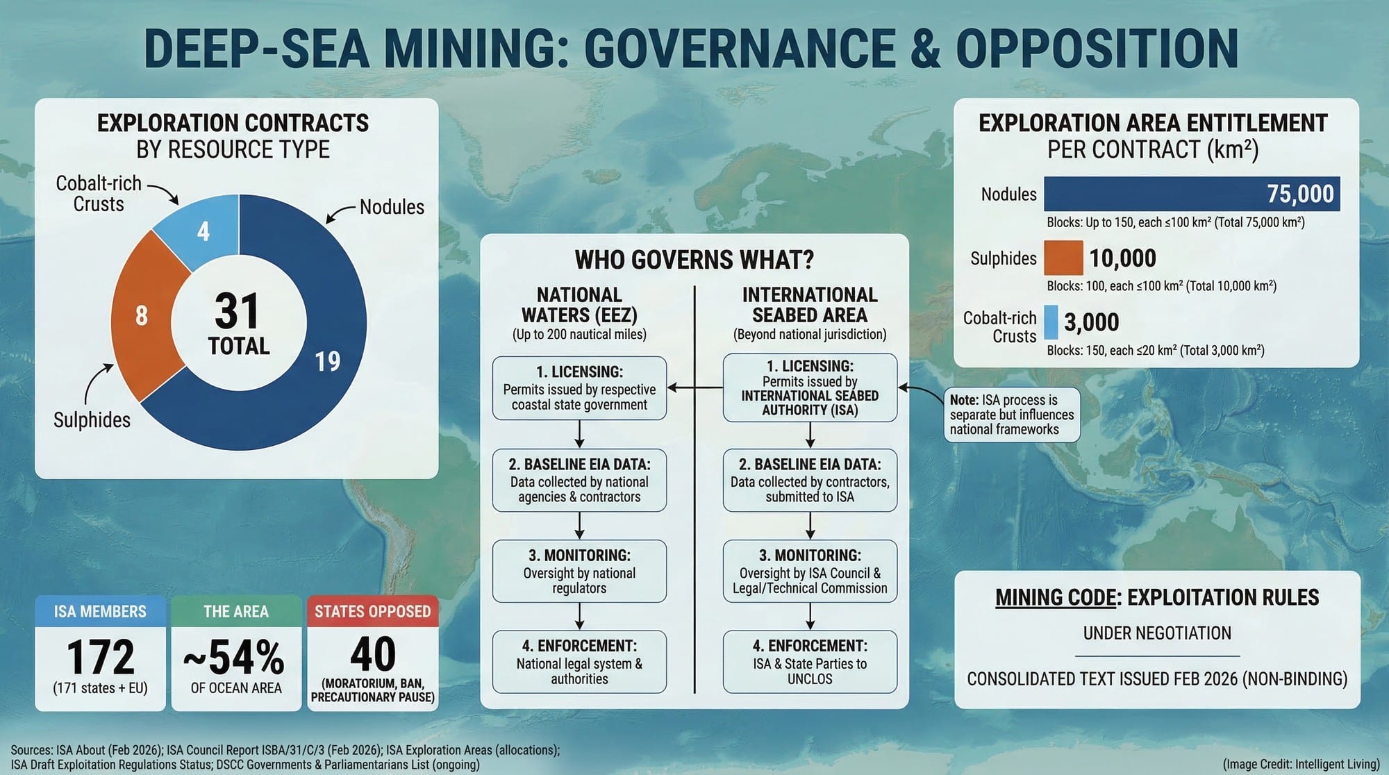
- The International Seabed Authority lists exploration contracts for nodules, sulfides, and cobalt-rich crusts, while exploitation regulations remain under negotiation, leaving commercial mining rules unfinished.
Such data capture a pivotal moment where exploration tools accelerate while extraction protocols remain in flux.
Exploration tools are accelerating. Extraction rules are not finalized. Environmental baselines are still incomplete.
First, Define The Terms: Underwater Exploration Vs. Deep-Sea Mining
What Is Underwater Mineral Exploration?
Survey teams use a variety of specialized tools to identify resource-rich areas in the abyss. These operations are critical for establishing geological baselines before any commercial decisions are made.
- High-resolution multibeam sonar for wide-area bathymetric mapping.
- Remotely operated vehicles (ROVs) for precision sampling and photography.
- Autonomous underwater vehicles (AUVs) for long-endurance environmental monitoring.
Marine scientists rely on these platforms to gather imagery and sediment samples. Such data provides a detailed look at the seabed without the need for constant surface support.
Research frequently prioritizes marine science over extraction, utilizing these surveys to establish vital biodiversity baselines. Surveys frequently incorporate baseline biodiversity studies, sediment analysis, and long-term monitoring.
Even with modern tools, most of the seafloor has not been mapped to modern standards. Exploration remains as much about basic discovery as it is about mineral potential.
What is Deep-Sea Mining?
Deep-sea mining involves the potential commercial extraction of mineral deposits such as polymetallic nodules, cobalt-rich crusts, or seafloor massive sulfides. Proposed projects frequently focus on the Clarion-Clipperton Zone in the Pacific Ocean, where polymetallic nodules contain trace metals such as Ni, Cu, Co, and Mn and a USGS assessment describes the area as the world’s most significant nodule field by both area and tonnage.
A key distinction is jurisdiction. Areas within a nation’s Exclusive Economic Zone fall under national regulation. Areas beyond national jurisdiction are governed through the International Seabed Authority, which is still finalizing its mining code.
The regulatory uncertainty is one reason exploration is moving faster than commercial mining approvals. In the United States, NOAA outlines how deep seabed mining is defined and regulated under U.S. law, including the permitting structure for exploration and potential recovery.

The Underwater Technology Surge: How AUVs and Sonar Expand Exploration Frontiers
The Ocean Data Boom
The most significant advancement in underwater mineral exploration is not a mining robot. It is the global expansion of ocean mapping.
Mapping Momentum: Seabed 2030, GEBCO, and Modern Coverage
Seabed 2030’s progress reports show steady growth in mapped coverage, reaching 27.3 percent of the ocean floor to modern standards. For perspective, back when 13% of the ocean floor was mapped in only the past 3 years, the pace already felt fast, and today’s coverage has moved beyond that baseline. Global terrain models like the GEBCO_2025 grid, improved sonar systems, and broader data sharing have directly fueled the current mapping surge.
Seabed mapping statistics can sound more complete than they are. Seabed 2030’s own roadmap describes a patchwork between regions mapped using modern multibeam techniques and areas where depth is inferred from satellite altimetry or older, lower-density surveys.
For mineral exploration and habitat science, that difference matters because a coarse grid can blur small seamounts, steep canyon walls, or subtle ridges where nodules and species can cluster.
How Multibeam Sonar Turns Echoes into Bathymetry
Oceanographers rely on high-frequency multibeam sonar systems to convert acoustic pulses into high-resolution terrain models. Since these systems generate hundreds of soundings per ping, they can create remarkably detailed topographic maps.
These surveys also record backscatter, which measures returned signal strength to indicate seafloor texture. Mapping teams must apply sound-speed corrections throughout the process to ensure the final depth calculations remain accurate.
NOAA’s standard ocean mapping protocol lays out how depth and backscatter are typically handled in modern survey workflows. The practical answer now involves long-endurance surveys, improved sonar, and autonomous platforms. Automation is also reshaping surface operations, where uncrewed vessels generate precise 3D terrain models during long-endurance missions.
Why AUV Autonomy Extends the Survey Frontier
Autonomous underwater vehicles add another layer. Platforms like Orpheus have conducted deep dives exceeding 5,600 meters and are designed for even greater depths. Underwater robots can collect high-resolution imagery and environmental data in areas where human-operated systems are impractical.
A useful benchmark for what autonomy can do is the AUV Sentry, which is rated to 6,000 meters and lists an operating range of roughly 70 to 100 kilometers per mission depending on speed and payload.
Endurance at that scale is what turns one expedition into repeatable mapping, where the same corridor can be surveyed again to check if features shift, instruments improve, or baseline measurements tighten. While a late-night watch on a research vessel might consist of quiet screens and steady progress bars, the true payoff emerges when a blurry slope resolves into a crisp, navigable surface.
Dual-Use Data: Minerals, Habitats, and Decision-Grade Maps
Modern seafloor data serves a dual purpose by informing both resource extraction and marine conservation. Reducing geological uncertainty through these maps allows stakeholders to identify mineral provinces and sensitive habitats with equal precision. Metadata packages frequently bundle the following products:
- A bathymetry grid that shows depth and slope
- Backscatter patterns that can suggest harder versus softer seabed
- Roughness and terrain metrics used to flag complex habitats
- Annotated features such as seamounts, canyon edges, and suspected nodule fields
Integrating these layers creates a comprehensive terrain model. This multidimensional approach ensures that regulators have a complete view of the underwater landscape before issuing permits.

Exploration is Accelerating: Here’s The Proof
Autonomy as a Force Multiplier for Deep-Ocean Surveys
Underwater mineral exploration is no longer limited to sparse ship-based surveys. Autonomous systems now enable repeatable missions and targeted site investigation. Even near the surface, tools like underwater drones that detect microplastics show how rapidly ocean robotics is evolving, and deep-ocean platforms are following the same autonomy arc.
Orpheus AUV and Direct Nodule Imaging
Recent updates from ocean exploration programs show AUVs imaging polymetallic nodules on the seafloor during dives exceeding 5,600 meters, turning predicted nodule sites into direct observations. It marks a shift from theory to direct observation.
Baseline Science: Biodiversity, Sediment, and Monitoring
Higher-resolution mapping also supports environmental baselines. Before any extraction could occur, regulators require detailed biodiversity and sediment data. The expansion of mapping and imaging capability therefore increases both mineral exploration and environmental assessment capacity.
Why Exploration Data Shapes Conservation and Policy
Researchers sometimes compare the deep ocean to a library without a catalog. Mapping is the catalog. Without it, neither conservation nor resource management is possible. With it, both become more precise.
Engineering Maturity: What Industrial Trials Demonstrate and What they Do Not
What the 2022 Sea Trial Proved in Practice
The 2022 industrial-scale polymetallic nodule collector trial, documented in peer-reviewed research, marked a significant engineering milestone. The 2022 sea trial demonstrated the potential of industrial-scale systems over 80 kilometers of terrain.
A peer-reviewed analysis of the 2022 sea trial confirms that the collector successfully recovered over 3,000 tonnes of polymetallic nodules during the test. The trial demonstrated mechanical feasibility at scale. It showed that collector vehicles, lift systems, and surface support vessels can operate together in deep-water conditions.
What it Still Cannot Prove: Cost, Plumes, and Cumulative Impact
However, it did not prove long-term economic viability or ecological acceptability. Sediment plumes, habitat disturbance, and cumulative impacts remain areas of active study. Engineering maturity does not equal regulatory approval.
Why Pre-Commercial Still Matters
This distinction is critical because prototype success does not equate to commercial readiness under finalized international law; while prototype trials have successfully demonstrated mechanical capacity, commercial production remains stalled until international rules are finalized. Prototype trials have occurred. Commercial production under finalized international rules has not.
Global Seabed Governance: Navigating Geopolitics, Permits, and The Mining Code
The Rulebook Isn’t Finished
Commercial deep-sea mining in international waters depends on the International Seabed Authority finalizing exploitation regulations. The ISA has confirmed that draft exploitation regulations remain under negotiation, covering environmental thresholds, financial terms, compliance mechanisms, and monitoring standards.
Regulatory gaps create significant tension among global stakeholders regarding extraction timelines.
- Developers and specific states argue that urgent critical mineral demand for electric vehicles requires accelerated permitting.
- Conservationists and other governments advocate for precautionary pauses until deep-sea environmental impacts are better understood.
Such debates were recently highlighted during the ISA Council’s March 2026 session schedule in Kingston, where observers noted a widening split in policy priorities.
These discussions described a widening split between states pushing for development and governments calling for a precautionary pause while rules and baseline science catch up. Liability frameworks, benefit-sharing mechanisms, and inspection protocols must be defined before commercial extraction can proceed legally in the international seabed area. Technology simply moved faster than the global rulebook could evolve.
National Moves are Reshaping The Landscape
While ISA negotiations continue, several countries are positioning themselves strategically.
Recent federal directives aim to prioritize offshore critical mineral resources as a pillar of national strategic security. In January 2026, NOAA finalized a consolidated exploration license and commercial recovery permit process, a change also captured in the Federal Register final rule text.
National interest signals do not override international governance in the Area, but it signals national interest in deep-sea resources. Japan has already conducted field tests where rare earth mud was successfully retrieved from a depth of approximately 6,000 meters. Government officials explicitly link this retrieval effort to long-term supply chain resilience.
Norway recently approved opening areas for seabed mineral activity, despite intense political pressure and legal scrutiny. However, the move continues to face significant political pressure and legal scrutiny from environmental groups.
Battery metals and rare earth magnets connect these policy moves to everyday technology, from electric motors to grid hardware. In that context, rare earth geopolitics in Greenland and Venezuela sit alongside the broader scramble for critical minerals powering decarbonizing technologies as governments weigh cost, security, and ecological risk.

Deep-Ocean Stewardship: Environmental Realities and Sustainable Resource Alternatives
Environmental Reality Check: Time Horizons Measured in Decades
Ecological surveys document that disturbances to the abyss often persist for decades, with geochemical changes rippling through entire marine ecosystems. USGS highlights that geochemical changes from nodule disturbance can ripple through marine ecosystems.
A long-term study revisiting a 1979 test site found that physical tracks remained visible more than forty years later, with signs of partial but incomplete biological recovery. Sediment plumes are another concern. When collector vehicles disturb the seabed, fine particles can spread beyond the immediate area.
Ongoing studies focus on how sediment plumes affect benthic organisms and midwater food webs. Recent research suggests that midwater mining discharge could disrupt midwater food webs by triggering bottom-up effects across mesopelagic ecosystems.
Assessing environmental risk involves navigating deep uncertainties rather than answering a simple binary question. These unknown variables underpin the growing calls for precautionary pauses and rigorous baseline data collection. The deep ocean is not an empty warehouse. It is a living ecosystem with slow recovery rates and limited human observation history. Discoveries such as Antarctic deep-sea coral gardens around seafloor vents are a reminder that “resource zones” can also be complex habitats.
The Solutions Ladder: Reducing Mining Pressure without Ignoring Mineral Demand
Even as underwater mineral exploration accelerates, reducing pressure on new extraction remains critical. In the Global E-waste Monitor 2024 key findings, researchers estimate the world generated a record 62 billion kilograms of e-waste in 2022, while only 22.3% was documented as formally collected and recycled. Closing that gap is one of the fastest ways to ease pressure on every mining frontier, including the seafloor.
Advanced recycling methods are now extracting precious metals from electronic waste far more efficiently than traditional smelting. The practical climate benefit is simple: every gram recovered is a gram that does not need to be mined, refined, shipped, and processed again.
Circular design principles extend product lifespans and reduce demand for virgin materials, and a circular battery economy built on recycling and reuse can keep nickel, cobalt, and other inputs in the loop longer. Analyses from the International Energy Agency characterize critical mineral recycling as indispensable for a secure energy transition but also note that collection, design, and scale-up determine how much recycling can realistically offset new demand in the near term.
Responsible sourcing frameworks aim to increase traceability across supply chains, especially as the critical minerals rush reshapes water access and community rights. Many companies now apply the OECD’s responsible mineral supply chain guidance to document where inputs come from and how risks are identified and mitigated across suppliers.
At the same time, better ocean mapping can support marine conservation planning. High-resolution data helps identify sensitive habitats before decisions are made.
A balanced path forward may involve multiple strategies: improved recycling, smarter material substitution, strict environmental guardrails, and transparent international governance, especially as critical mineral breakthroughs keep reshaping supply-chain priorities year to year.
Global demand continues to surge, with lithium requirements rising by nearly 30% in 2024 alone as energy applications expand. For many households, one of the fastest pressure-release valves is simply keeping devices in service longer. Legislative progress in Right to Repair initiatives represents a critical shift toward reducing the overall demand for virgin minerals.
We must view ocean mapping as stewardship infrastructure, not just resource prospecting, to properly reframe the conversation. This data is most powerful when paired with the economic benefits of global ocean conservation rather than treated as a one-way resource pipeline.

Conclusion: What You Can Do This Week
Consumers do not control international seabed negotiations. But everyday decisions still shape mineral demand.
A phone that gets a battery replacement instead of an upgrade is a small act on the surface, but it can represent a real reduction in upstream mining, refining, and shipping. In daily life, that choice often looks like a repaired device that keeps working for two more years, not a grand statement.
- Extend the life of electronics through repair programs.
- Choose refurbished devices when possible, since the eco-friendly appeal of refurbished tech is often the fastest way to cut demand for newly mined metals.
- Choose certified recycling channels for e-waste that treat electronic recycling as a way to recover high-value metals rather than exporting pollution.
- Support policies that require supply chain transparency.
- Stay informed about how ocean mapping and marine conservation intersect.
Navigating The Future of Deep-Ocean Stewardship
The shift from speculative prospecting to data-driven exploration marks a pivotal moment in the global relationship with the deep ocean. Rather than viewing the seafloor as a mere warehouse of raw materials, modern high-resolution mapping treats the abyss as a complex habitat requiring precise management.
Underwater mineral exploration is advancing. Success in this new era will not be measured solely by the tonnage of minerals recovered but by the integrity of the environmental guardrails established before the first commercial machines touch the seabed.
Deep-sea mining’s future as a commercial reality will depend not only on engineering but also on science, governance, and collective priorities. While technology continues to expose the vast wealth of the ocean floor, a collective commitment to sustainability and transparent governance will determine if these ecosystems are protected or if past industrial mistakes are repeated.
The same habits that reduce e-waste and extend product lifetimes also reduce pressure to push extraction into places where baseline science is thin and recovery may take decades.

Deep-Sea Mining and Ocean Mapping FAQ
What is The Primary Difference Between Exploration and Deep-Sea Mining?
Underwater mineral exploration focuses on surveying, mapping, and sampling to understand geological formations, whereas mining involves the commercial-scale extraction of mineral deposits for industrial use.
Where is The Clarion-Clipperton Zone Located?
The Clarion-Clipperton Zone (CCZ) is a vast abyssal plain in the Pacific Ocean between Hawaii and Mexico, known for having the world’s largest concentration of polymetallic nodules.
What are The Main Environmental Risks of Deep-Sea Extraction?
Primary concerns include the disruption of benthic habitats, the spread of sediment plumes that can choke marine life, and long-term geochemical changes that may take decades to recover.
How Do AUVs Improve Seafloor Mapping Accuracy?
Autonomous underwater vehicles (AUVs) can dive closer to the seabed than surface ships, using high-frequency sonar to capture centimeter-scale imagery and precise topographic data.
Can Recycling Reduce The Need for Deep-Sea Mining?
Yes. Improving e-waste recovery and adopting circular battery economies can significantly offset the demand for virgin minerals like nickel, cobalt, and lithium.


