
South Korea is engineering a comprehensive intelligence architecture to track and interpret environmental shifts across our land, oceans, and atmosphere, moving past the simple deployment of orbital hardware. As we navigate a landscape defined by volatile harvests and rising pollution, the capacity for real-time Earth observation has evolved from a scientific luxury into essential social infrastructure.
Modern remote sensing utilizes orbital sensors to gather vital data from the Earth’s surface, allowing us to perceive global changes without setting foot on the ground. These systems capture optical imagery, radar signals, and atmospheric data. Integrating artificial intelligence transforms these orbital snapshots into actionable intelligence for the communities and leaders tasked with safeguarding resources.
Specialized programs generate high-fidelity environmental data through the Korea Multi-Purpose Satellite program, or KOMPSAT. Managed by the Korea Aerospace Research Institute, the constellation produces high-resolution optical, radar, and infrared imagery that supports land management, disaster monitoring, marine observation, agriculture, forestry, environmental tracking, and national security functions.
According to South Korea’s national satellite application program, the national fleet generates roughly 100,000 high-resolution images annually across multiple payload types. Satellite connectivity unites ground stations, AI analytics, and agri-tech platforms into a continuous monitoring loop.
For farmers asking how to reduce fertilizer waste or coastal planners watching harmful algae blooms, satellite data is quietly becoming part of everyday resilience. Similarly, for city officials responding to wildfire smoke, these orbital insights offer the situational awareness needed to protect public health. Observation patterns increasingly include soil moisture sensors and satellite-guided crop monitoring, where ground measurements and overhead imagery work better together than either one does alone.
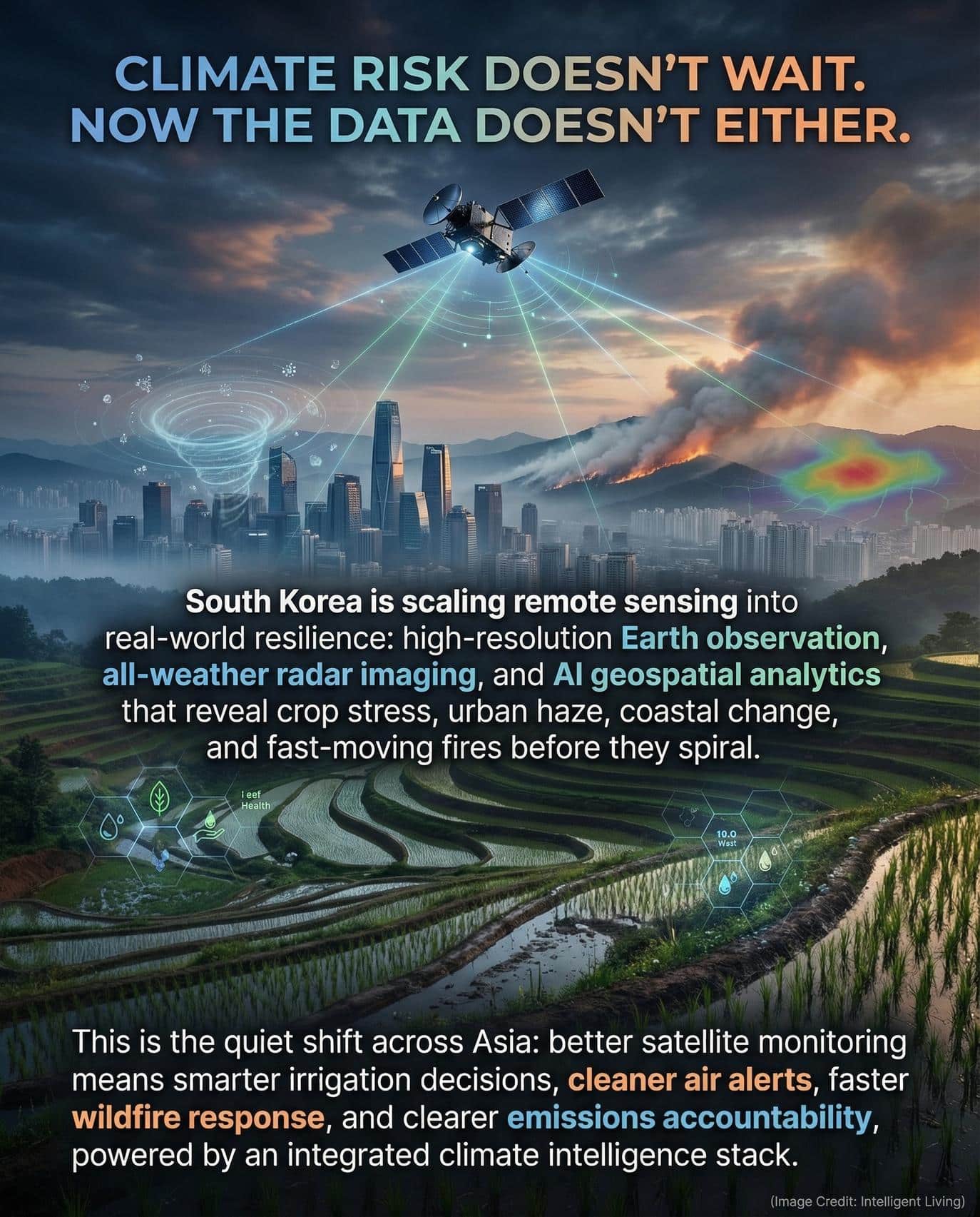
Quick Facts About South Korea’s Remote Sensing and Climate Intelligence Market
Evaluating the scale of this technological leap requires a look at the specific capabilities currently active in South Korean orbits. These benchmarks illustrate how the nation is translating high-level space policy into measurable environmental outcomes.
- KOMPSAT satellites generate approximately 100,000 high-resolution images per year across optical, radar, and infrared payloads, according to the Korea Aerospace Research Institute.
- National funding allocating 1.1201 trillion KRW to satellite-based navigation and observation signals so that remote sensing is viewed as strategic infrastructure.
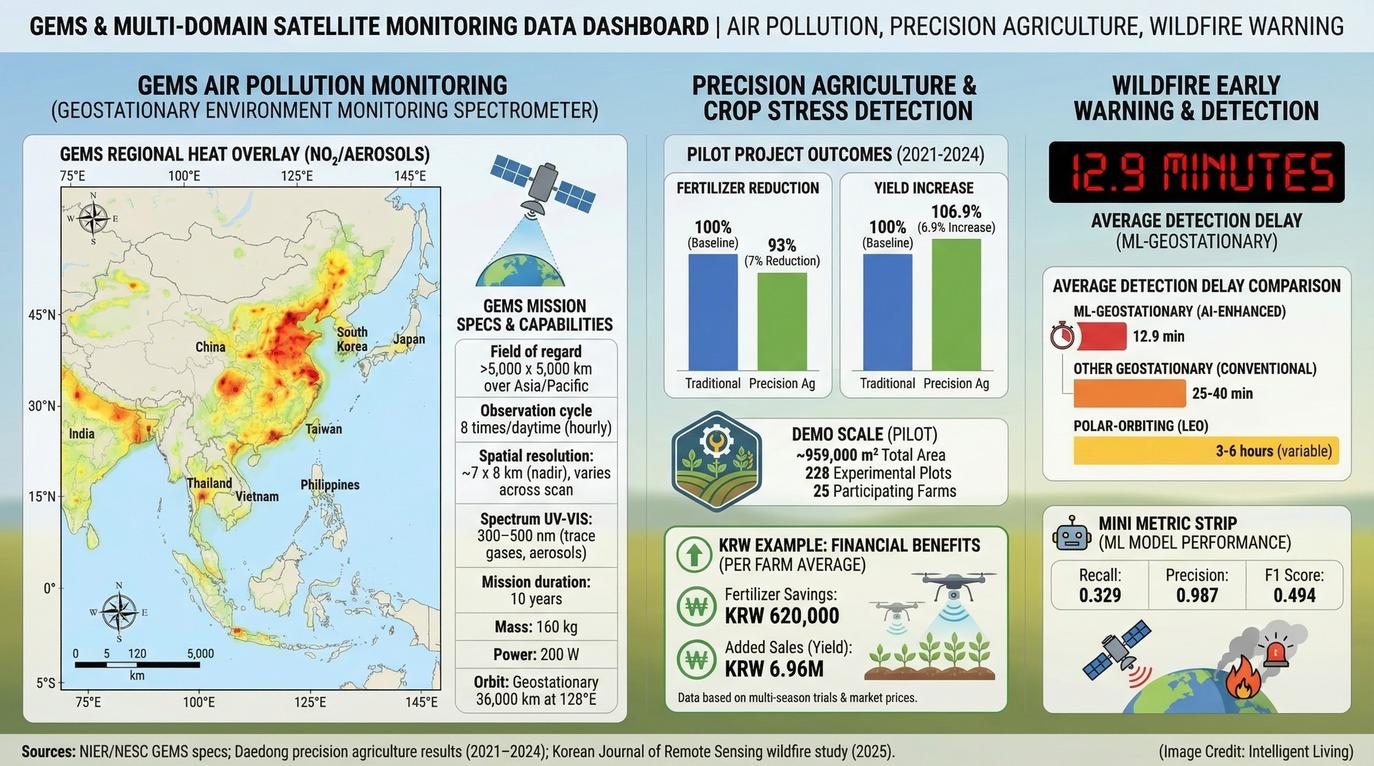
- The Geostationary Environment Monitoring Spectrometer onboard Cheollian 2B observes ozone, nitrogen dioxide, sulfur dioxide, formaldehyde, aerosols, and other pollutants across a 5,000 kilometer by 5,000 kilometer field covering 27 East Asian countries with up to eight observations during the daytime.
- Sejong 1, developed by HANCOM InSpace, was South Korea’s first commercial Earth observation satellite and includes a red edge band optimized for vegetation index analysis of crops and forests.
- A recent technical review found that leveraging geostationary satellite data for wildfire detection can result in an average lag time of only 12.9 minutes.
Technical milestones of this caliber form the data-driven foundation of a safer, more predictable regional environment. By monitoring these variables continuously, South Korea provides the transparency needed to address climate volatility at scale.

Climate Resilience and the Role of Critical Satellite Infrastructure
Measurable shifts in our climate now manifest as frequent crop failures, extended wildfire seasons, and heightened marine ecosystem stress. Remote sensing allows those changes to be measured consistently across large geographic areas.
Modern environmental management depends on these orbital eyes to provide historical context and real-time alerts. Without this infrastructure, tracking the rapid migration of pollutants or the desiccation of soil would remain a reactive, ground-based struggle.
From Imagery to Decision Infrastructure
Orbital snapshots once restricted to mapping and intelligence roles now support vital water resource management and forestry planning. Today, these tools are essential for rapid disaster response and environmental monitoring. The Korea Aerospace Research Institute explicitly lists agriculture, marine monitoring, water resources, environmental observation, and disaster tracking among its national satellite applications.
The same pattern is visible in advanced irrigation and water management technologies, where better data leads to more precise and timely environmental decisions. In practical terms, satellite imagery can help determine where irrigation efficiency is failing, where soil moisture is declining, and where algae blooms threaten reservoirs.
Environmental strategists often seek clarity on a specific challenge: “how can satellite data help manage climate risk?” Consistent, repeatable measurement across vast geographic expanses provides the necessary answer where thousands of ground sensors would otherwise be required.
Why Climate Risk Makes Earth Observation More Valuable
As climate volatility increases, so does the need for rapid updates. Wildfires that once developed over days can now intensify within hours. Air pollution can travel across borders in a single weather system. Farmers managing thousands of hectares need frequent data, not annual surveys.
Delivering frequent revisits provides the temporal resolution necessary to catch disasters in their early stages via these satellite constellations. Rapid temporal resolution is becoming the benchmark for climate-resilient planning in agriculture and urban safety.
South Korea’s geostationary environmental satellite Cheollian 2B carries the Geostationary Environment Monitoring Spectrometer, which tracks major atmospheric pollutants across much of East Asia multiple times each day. That capability transforms remote sensing into a regional climate monitoring service rather than a purely domestic tool.
A small farmer in South Jeolla Province might not think about orbital spectrometers. But when fertilizer costs rise and rainfall patterns shift, vegetation index data derived from satellites can directly influence planting decisions. That is how climate intelligence moves from orbit to field and into the larger search for water scarcity solutions for agriculture in increasingly dry growing regions.

Building the National Backbone: South Korea’s Public Observation Architecture
Public infrastructure serves as the bedrock for South Korea’s remote sensing ambitions.
KOMPSAT and the State Observation Architecture
By generating high-resolution optical and radar imagery, the KOMPSAT program provides the public layer of South Korea’s observation infrastructure. Radar-based satellites use synthetic aperture radar, often abbreviated as SAR, which can image the Earth’s surface through clouds and at night. Constant observation remains critical during typhoon season and wildfire smoke events when optical imagery may be obstructed.
Utilizing SAR technology ensures that South Korean environmental observation remains uninterrupted by adverse weather conditions. Reliability of this type is the cornerstone of the national disaster monitoring strategy.
Strategic Space Policy and Sustainable Funding Models
Specialized sensors operated by KARI sharpen observation of red tides and marine pollution across vulnerable coastal waters. These applications directly support fisheries, shipping, and satellite-based ocean health monitoring across vulnerable coastlines.
Strategic funding on this scale suggests that remote sensing is viewed as essential infrastructure rather than a niche research project. Public funding reduces technological risk and provides baseline demand, allowing private firms to build services on top of the national backbone.
Mapping the Commercial Market: Private Sector Remote Sensing Services
Commercial innovation in South Korea now extends far beyond government-funded satellites.
Satellite Makers and Imaging Providers
With the deployment of the Sejong 1 Earth observation satellite, HANCOM InSpace introduced South Korea’s first commercial Earth observation satellite featuring a specialized red edge band for vegetation analysis. Red edge spectral bands detect subtle changes in plant health that traditional RGB imagery cannot capture, using the same spectral logic behind multispectral satellite data used to verify land use change across regulated landscapes.
The Satrec Initiative has introduced a system designed for achieving 25 centimeter class Earth observation imagery for urban planning and infrastructure inspection. High-resolution imagery at this scale enables detailed urban planning, infrastructure inspection, agricultural monitoring, and the broader shift toward carbon-aware smart city operations in fast-growing urban areas.
AI Geospatial Analytics and Decision Platforms
Raw imagery gains value only when interpreted. One example includes SI Analytics’ AI geospatial intelligence platform, which applies machine learning to resource monitoring, urban planning, climate prediction, and national defense.
Automated analysis enables authorities and businesses to rapidly identify:
- Critical crop stress and soil moisture declines.
- Unauthorized construction or land-use changes.
- Evolving flood patterns in vulnerable flood risk areas.
- Early deforestation signals across protected forests.
Actionable insights emerge via geospatial intelligence for urban planning once algorithms successfully convert raw pixels into measurable indicators.
Environmental Services and Ground Infrastructure
Several firms such as CONTEC Earth Service are now building greenhouse gas monitoring and carbon-related analytics on top of domestic and global satellite imagery. The company has outlined plans for environmental satellites aimed at emissions tracking and sustainability reporting.
The commercial layer also includes Nara Space’s integrated satellite and imagery model, which spans satellite development, imagery platforms, and data analysis services. Maturing ecosystems across the sector reflect a shift where firms do not simply sell hardware but deliver high-value information products.
Expanding the Environmental Economy through Precision Climate Monitoring
The most commercially resilient layer of the remote sensing market is climate monitoring.
Air and Atmospheric Monitoring Across East Asia
The Geostationary Environment Monitoring Spectrometer observes ozone, nitrogen dioxide, sulfur dioxide, and aerosols across 27 East Asian countries. Capturing up to eight daytime observations provides near-continuous updates on air pollution patterns throughout the region. Enhanced monitoring supports cross-border environmental policy and the broader push toward satellite-based air pollution tracking across major cities.
Agriculture, Crop Stress, and Precision Farming
South Korea’s agri-tech layer includes satellite-based precision agriculture tools developed by Daedong and KT SAT. Recent demonstration projects have reported measurable fertilizer reductions alongside significant yield improvements. Parallel to this, field practices focused on soil health and moisture retention illustrate how improved ground conditions amplify the overall value of remote-sensing data.
Agricultural producers frequently investigate the potential of space assets, asking “[how to increase crop yield with satellite imagery]” to access vegetation index maps, fertilizer prescription tools, and seasonal trend data. These services align closely with smart agriculture trends already reshaping food systems and with soil-biodegradable crop coverings that change field moisture and pest pressure in water-stressed fields.
Wildfire Detection and Faster Disaster Response
A recent technical review found that leveraging geostationary satellite data for wildfire detection can result in an average lag time of only 12.9 minutes. Shaving even minutes off detection time can influence containment outcomes.
Communities living in wildfire-prone regions increasingly rely on early warning systems as the growing threat of wildfires in a changing climate becomes harder to ignore. Providing responders with faster situational awareness allows satellite-based detection to serve as a critical multiplier for ground teams.
Industrial Decarbonization and the Role of Carbon Analytics
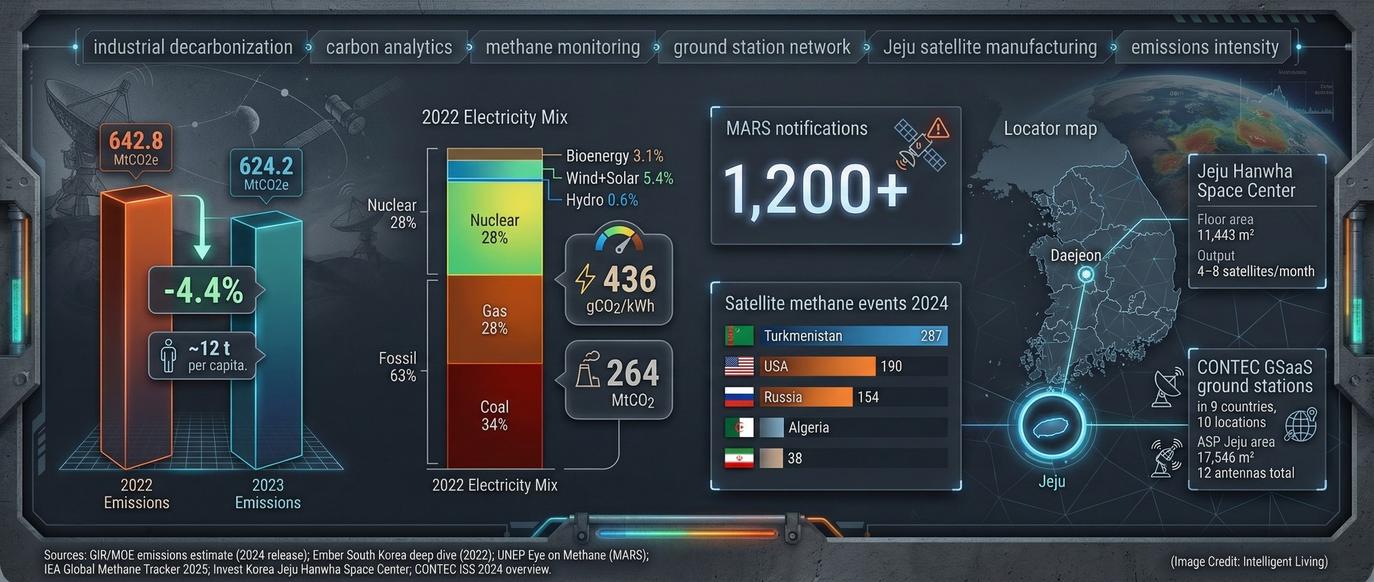
CONTEC Earth Service has outlined greenhouse gas monitoring and carbon analytics platforms intended to support emissions tracking and sustainability reporting.
Supply chains now face mounting pressure for greater transparency, leading to the rise of satellite-derived emissions monitoring as a pillar of environmental accountability. Global efforts such as tracking super-emitters from orbit mirror this transition. Targeted identification of methane emissions revealed by satellite imagery additionally supports the monitoring of volatile global energy supply chains.
Precision climate monitoring addresses several critical sectors simultaneously:
- Sustainable agriculture and precision farming.
- Regional pollution control and air quality.
- Disaster risk reduction and emergency response.
- Global carbon markets and emissions accountability.
Why Place Still Matters: Jeju, Daejeon, And Korea’s Emerging Space Geography
The sophisticated digital outputs of remote sensing rely on a sprawling physical industrial base. Daejeon and Jeju Island have emerged as critical nodes for manufacturing and data processing.
Industrial specialization has created distinct geographic nodes for remote-sensing expertise:
- Daejeon: Serves as the primary research hub, hosting the Korea Aerospace Research Institute alongside several private satellite manufacturers.
- Jeju Island: Functions as a critical manufacturing and data utilization node, supported by expanding private ground stations and satellite production centers.
Localized Ground Stations and Data Downlink Infrastructure
Geographic hubs such as these provide the physical foundation for regional climate intelligence. Daejeon supports collaboration, talent development, and the kind of climate-aware urban planning used to respond to the urban heat island effect in rapidly warming cities.
An engineer relocating to Jeju for satellite manufacturing might not describe it as climate infrastructure. Yet the factories and ground antennas form the tangible backbone of climate intelligence services.

Aerospace Intelligence Synergy and the Advancement of Regional Environmental Security
Leveraging Defense Multipliers for Enhanced Environmental Observation
Defense demand has accelerated certain technical capabilities. South Korea’s industrial depth also reflects Hanwha Systems’ work on electro-optical infrared and synthetic aperture radar payloads alongside recent advancements in electro-optical infrared systems.
While defense is not the emotional center of this story, it contributes to industrial depth. Technologies developed for national security can spill into civilian markets, improving disaster monitoring and environmental observation.
Maximizing Orbital Assets for Strategic Climate Intelligence Solutions
The long-term value of orbital sensors rests on their conversion into actionable decision systems. This strategic integration turns raw data into regional climate leadership.
South Korea’s combination of public investment, commercial imaging platforms, AI analytics, agricultural applications, and greenhouse gas monitoring services suggests a strategic direction. This approach aligns with the rise of geospatial MRV systems that turn satellite evidence into auditable environmental accountability.
Strategic positioning allows South Korea to serve as a regional provider of climate-relevant data services rather than merely a satellite operator.
Diverse stakeholders rely on consistent, high-frequency observation to meet specific goals:
- Policymakers planning for flood risk areas.
- Farmers optimizing fertilizer and resource use.
- City planners monitoring urban heat islands.
If South Korea can integrate sensing, analytics, and sector-specific tools into a cohesive platform, it strengthens its case as a remote sensing nerve center for Asia.
Escalating Climate Risk and Resilient Food Security
National remote sensing strategies are evolving to meet the demands of a volatile environment. Escalating climate risk is turning satellite observation into everyday infrastructure to ensure resilient food security as mounting environmental pressures impact the region. The integration of KOMPSAT, Cheollian 2B, AI geospatial analytics, agri tech services, and emerging greenhouse gas monitoring platforms reveals a market that extends far beyond image sales.
Rather than chasing prestige alone, the country is investing in the tools required to measure air quality, crop health, wildfire activity, marine ecosystems, and emissions patterns across East Asia. In a region facing escalating environmental pressure, climate intelligence may prove more valuable than rockets.

Cultivating a Data-Driven Future for Regional Climate Resilience
South Korea’s strategic investment in high-resolution Earth observation data signifies a profound commitment to long-term environmental stability. Bridging the gap between sophisticated space-based climate infrastructure and practical on-the-ground applications empowers farmers, city planners, and environmental policymakers with unprecedented clarity. The true value of this intelligence stack lies not in the hardware alone, but in converting complex orbital signals into the daily tools required to safeguard our ecosystems and resources.
As the regional climate monitoring market matures, South Korea’s role as a primary provider of environmental intelligence in East Asia is likely to expand. The seamless integration of KOMPSAT imagery, AI-driven geospatial analytics, and localized agri-tech platforms creates a blueprint for leveraging space assets for sustainable growth. Implementing these data-driven strategies offers a clear path toward a more resilient and climate-aware future for the entire region.
Frequently Asked Questions: Navigating South Korea’s Remote Sensing Advancements
How does South Korea’s remote sensing impact local food security?
Satellite-based crop monitoring and soil moisture sensors identify early stress, allowing farmers to optimize irrigation and fertilizer use to stabilize harvests under climate pressure.
Why is KOMPSAT essential for regional disaster risk management?
The constellation provides high-frequency radar and optical imagery, which helps authorities track wildfire detection lag times and coastal flooding in near real-time.
What makes the GEMS spectrometer on Cheollian 2B unique?
GEMS is the first geostationary environmental monitoring sensor, tracking major atmospheric pollutants across 27 East Asian countries multiple times throughout the day.
Can satellite imagery analysis help reduce urban heat island effects?
High-resolution imagery identifies thermal patterns and vegetation gaps, enabling city planners to design smarter, cooler environments and carbon-aware smart city operations.
How does the 2026 national space budget support private satellite makers?
National funding allocates significant capital to strengthen the private space industry ecosystem, encouraging startups to develop innovative commercial remote-sensing services and analytics platforms.


